Airline Weather
Industry Solutions
Explore real-world use cases and solutions tailored to each industry's unique weather challenges.

Construction Weather

Logistics Weather

Facility & Plant Weather

Municipal Weather

Retail Weather

Energy Weather

Dam Weather

Insurance Weather

Agricultural Weather

School Weather

Event Weather

Sports Weather

Road Weather

Railway Weather

Climate Tech

Broadcasting Weather

Coastal Weather

Airline Weather

General Aviation Weather

Drone Weather
Weather Solutions
Industry Solutions
Top PageWeather Solutions
Surging Fuel Prices Hit Airline Operations
April 2, 2026 Weathernews

A sharp rise in jet fuel prices, driven by tensions in the Middle East, is beginning to affect airline operating plans worldwide.
Airlines have successively announced flight reductions and transitions to emergency management measures. As fuel costs surge, the financial risks associated with weather-related operational disruptions are becoming greater than ever.
Following the military conflict in the Middle East, the price of jet fuel (Jet A-1) has surged sharply. Over the past few weeks, fuel prices have risen rapidly, prompting several airlines to move ahead with fare increases and reductions in flight frequencies. The Civil Aviation Authority of Vietnam (CAAV) has also issued a warning that supply constraints of Jet A-1, stemming from the Middle East situation, are increasing the risk of fuel shortages for domestic airlines.
・Vietnamese Airlines According to a Reuters report (March 27, 2026), Vietnamese airlines are reviewing their operating scale in response to rising fuel prices. Flag carrier Vietnam Airlines is considering suspending or reducing some domestic routes, while LCC VietJet Air is also planning to scale back operations. Bamboo Airways is reportedly preparing to significantly reduce its daily flight numbers. Meanwhile, Sun PhuQuoc Airways is expected to maintain its current schedule for the time being. To help stabilize the domestic market, the government has reportedly introduced temporary measures to suspend part of the fuel tax, including taxes on aviation fuel.
・Korean Air According to a Reuters report (March 31, 2026), Korean Air will shift into an emergency management mode from April 2026 in response to rising crude oil prices. The airline plans company-wide measures centered on cost reductions and a review of fuel surcharges.
・United Airlines In a message to employees, CEO Scott Kirby said the airline plans to reduce capacity by about 5% in the short term. Fuel prices have more than doubled over the past three weeks, and if the current level persists, the airline estimates an additional annual fuel cost of approximately $11 billion. At the same time, the airline emphasized resilient demand, noting that booking revenue for the next 10 weeks remains at the highest level in the company’s history.
・Cathay Pacific In an official statement, the airline said it will increase fuel surcharges starting March 18, 2026, in response to higher aviation fuel prices linked to the Middle East situation. The surcharge will be reviewed monthly in line with fuel price trends.
Similar moves are being seen across the global aviation industry, with airlines adjusting capacity and implementing cost-reduction measures in response to higher fuel prices.
When fuel costs surge, the implications of weather-related operational disruptions fundamentally change.
Under normal circumstances, an unexpected weather-driven diversion might simply be treated as an operational cost increase. However, with fuel prices now roughly twice their previous level, the same diversion can translate into a substantial cost escalation. A diversion to an alternate airport is no longer just an operational adjustment—it may require an emergency management decision. Likewise, when dealing with ground delays or cancellations, the trade-off between fuel conservation and passenger compensation becomes a strategic issue at the management level.
In this environment, shifting the response to weather risk from reactive to proactive is no longer merely a matter of operational efficiency—it becomes a critical element of cost control.
References: Reuters (March 27, 31, 2026) United Airlines (March 21, 2026) Cathay Pacific (March 12, 2026)
Explore real-world use cases and solutions tailored to each industry's unique weather challenges.
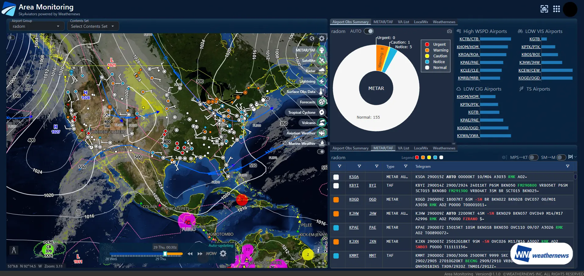
SkyAviators is a comprehensive weather information platform developed by Weathernews for the aviation industry. Combining world-class meteorological data with decades of specialized expertise in aviation weather, it empowers airlines to make operational decisions. The Area Monitoring function monitors the development, movement, and expansion of rain clouds over a wide area. It enables early identification of affected airports and air routes, allowing for strategic operational decisions before impacts occur.
View the weather status of your entire monitoring area on a single, integrated screen. By overlaying essential data—such as radar, satellite, snowfall, lightning, and turbulence—operators can intuitively grasp everything from localized phenomena to large-scale weather patterns.
Create a comprehensive list of monitored airports with automated color-coding based on pre-set operational impact thresholds. This allows operators to instantly identify the risk level of each airport, ensuring that those requiring immediate attention are prioritized at a glance.
Monitor both real-time conditions and future forecasts for each airport on a single, integrated interface. With both current and predicted data color-coded by severity, operators can seamlessly track evolving risks from the present moment into the future.
Customizable monitoring areas and target airports tailored to your flight network. Whether focusing on major hubs, key routes, or specific regions, the system enables monitoring aligned with your operational policies.
By simultaneously visualizing wide-area weather patterns and airport-specific risks, users can detect potential operational impacts at an early stage.
The color-coded display clearly identifies which airports or regions require immediate attention. This streamlines the sharing of situational awareness between air traffic control and flight operations teams.
By integrating real-time monitoring with weather forecasts, the system supports advanced decision-making for aircraft and crew scheduling, as well as flight schedule adjustments.
By reducing unexpected cancellations and delays, the system contributes to enhanced operational stability and the maintenance of high customer satisfaction levels.
Please feel free to consult with us about implementation methods, features, or advancing specific considerations. We'll answer even the smallest questions.
We'll explain pricing details and provide specific content based on your site conditions so you can consider with confidence.
Free Quote
We'll explain in detail how to utilize features and the implementation process. Please feel free to consult with us.
Consider Implementation