Airline Weather
Industry Solutions
Explore real-world use cases and solutions tailored to each industry's unique weather challenges.

Construction Weather

Logistics Weather

Facility & Plant Weather

Municipal Weather

Retail Weather

Energy Weather

Dam Weather

Insurance Weather

Agricultural Weather

School Weather

Event Weather

Sports Weather

Road Weather

Railway Weather

Climate Tech

Broadcasting Weather

Coastal Weather

Airline Weather

General Aviation Weather

Drone Weather
Weather Solutions
Industry Solutions
Top PageWeather Solutions
The Yellow Dust Season Arrives — Spring Sand and Dust Transport Threatens Flight Operations
March 5, 2026 Weathernews
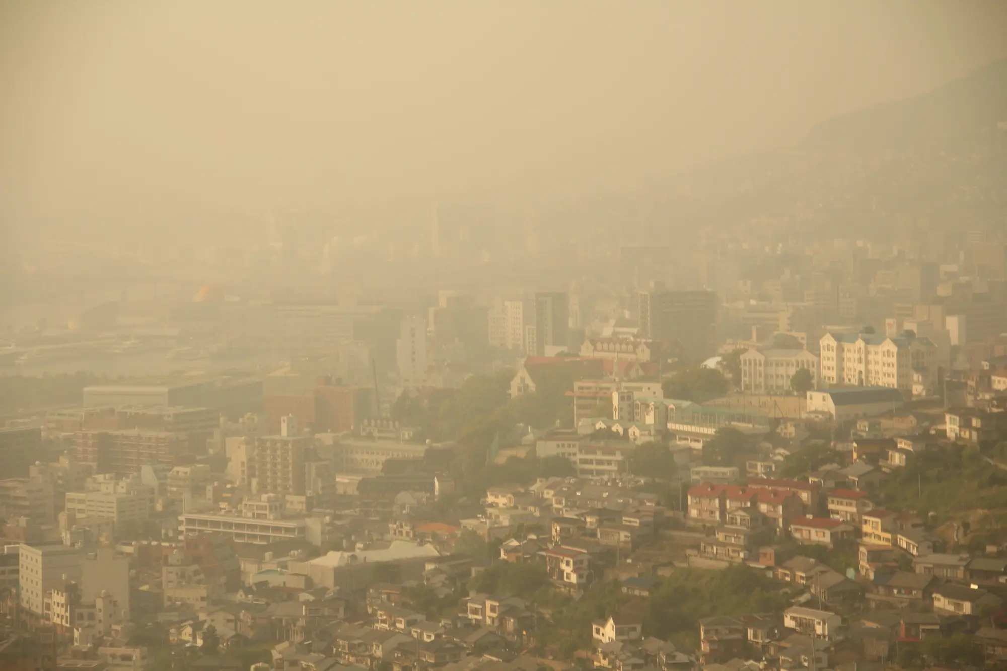
Across airports in East Asia, yellow dust events occur mainly in spring, causing widespread reductions in visibility.
Unlike thunderstorms or fog, yellow dust can simultaneously affect areas spanning several hundred to several thousand kilometers, constraining operations at multiple airports at once. Understanding the seasonal transport patterns is essential for establishing stable and reliable flight operation plans.
The yellow dust phenomenon refers to the uplift of large quantities of sand and dust (sand particles and fine dust) by strong winds from desert regions in East Asia—such as the Gobi Desert and the Taklamakan Desert—as well as from loess areas. These particles are then transported by upper-level winds, remaining suspended in the atmosphere before gradually settling.
In China, “sand-dust weather (yellow dust)” is classified into three categories: floating dust, blowing sand, and sand-dust storm.
・Floating dust: Under calm or weak wind conditions, sand and fine particles remain uniformly suspended in the air, with visibility within 10 km. It is caused by transported dust from distant sources or residual airborne dust following sand-dust storms or blowing sand events.
・Blowing sand: Relatively strong winds lift surface sand and dust, reducing visibility to 1–10 km.
・Sand-dust storm: Strong winds raise large amounts of sand and dust, reducing visibility to less than 1 km. In particularly intense cases—instantaneous wind speeds of 25 m/s or higher (Beaufort scale 10 or above)—visibility may drop below 50 m. Such severe events are referred to as “Black Wind” or “Black Storm.”
In contrast, yellow dust events in Japan are often not accompanied by strong surface winds, and therefore “sand-dust weather” and “yellow dust” are not directly equivalent. The Japan Meteorological Agency defines yellow dust as “a phenomenon in which large quantities of sand particles, mainly lifted from the continental loess regions, cover the sky and gradually settle.” Observations are conducted visually. When visibility is below 10 km with present weather code 06, the event is recorded as an atmospheric phenomenon; since April 1989, cases with visibility of 10 km or more are also recorded as “yellow dust” if clearly observed.
In Korea, yellow dust is referred to as “Hwangsa.” Observations are conducted visually, and intensity is recorded in three levels (0–2) according to the degree of dust transport.
Source:Ministry of the Environment — Yellow Dust–Related Information
Category
Eight Major Deserts in China
Four Major Sandy Lands in China
Mongolia
Region
Taklamakan Desert, Gurbantünggüt Desert, Kumtag Desert, Qaidam Basin Desert, Badain Jaran Desert, Tengger Desert, Ulan Buh Desert, Kubuqi Desert
Horqin Sandy Land, Hunshandake Sandy Land, Mu Us Sandy Land, Hulunbuir Sandy Land
Southern Gobi region
Yellow dust transport peaks during spring (March–May). This seasonal concentration is driven by distinct meteorological mechanisms.
Winter (December–February): Why Yellow Dust Is Limited
・Although precipitation is low, surface soils are often covered by snow, suppressing dust uplift.
・The Siberian High dominates, and near-surface winds are relatively weak.
・The jet stream is positioned farther south, making transport pathways toward Japan less likely to form.
Spring (March–May): Why Yellow Dust Increases Sharply
・Snow cover melts, exposing dry, bare soil.
・Strengthened westerlies enhance long-range dust transport.
・Cyclones frequently develop over the continent, generating strong surface winds.
・The jet stream shifts northward, establishing a transport route over western Japan.
・As continental low-pressure systems and fronts move eastward, dust located near or behind these systems is lifted by strong winds and transported toward Japan and Korea.
From Summer Onward (June–): Why Yellow Dust Decreases
・Increased precipitation removes airborne dust through wet deposition.
・Vegetation growth stabilizes and covers the land surface.
・Autumn records the lowest annual frequency of yellow dust events.
・Even when ground visibility appears adequate, the runway may not be clearly visible from the air during approach.
・In dense yellow dust conditions, visibility can fall below 1,000 m, potentially requiring higher landing categories or even airport closure.
・Because yellow dust affects wide areas, multiple airports may experience simultaneous visibility reductions, making it difficult to secure suitable alternates.
・Ingestion of sand and dust particles into aircraft engines can cause blade erosion and performance degradation.
Explore real-world use cases and solutions tailored to each industry's unique weather challenges.
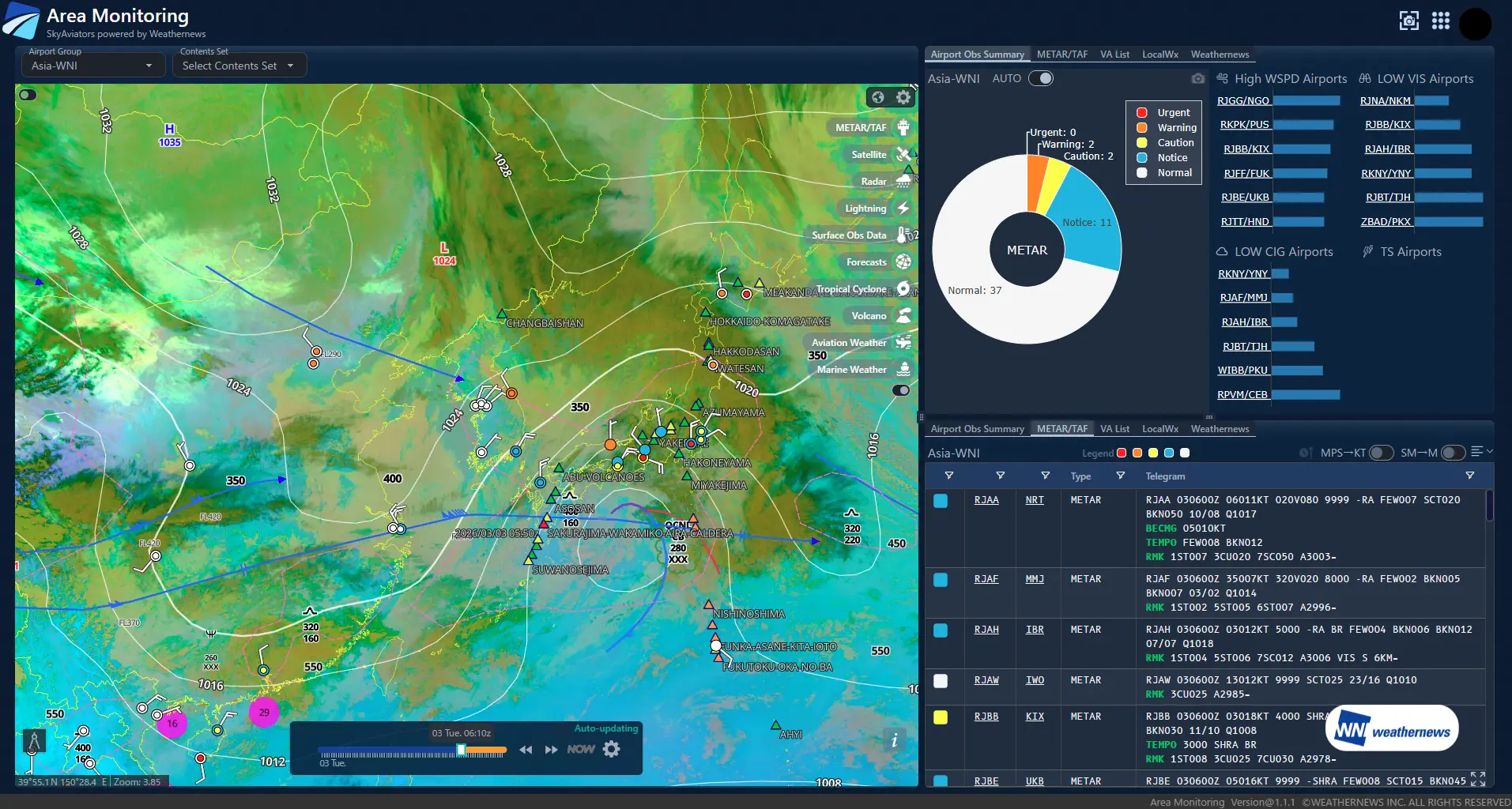
SkyAviators is a comprehensive weather information platform developed by Weathernews for the aviation industry. Combining world-class meteorological data with decades of specialized expertise in aviation weather, it empowers airlines to make operational decisions. Area Monitoring function monitors the movement and spread of yellow sand over a wide area, allowing you to quickly identify affected airports and air routes, enabling strategic response before operational impacts occur.
View the weather status of your entire monitoring area on a single, integrated screen. By overlaying essential data—such as radar, satellite, snowfall, lightning, and turbulence—operators can intuitively grasp everything from localized phenomena to large-scale weather patterns.
Create a comprehensive list of monitored airports with automated color-coding based on pre-set operational impact thresholds. This allows operators to instantly identify the risk level of each airport, ensuring that those requiring immediate attention are prioritized at a glance.
Monitor both real-time conditions and future forecasts for each airport on a single, integrated interface. With both current and predicted data color-coded by severity, operators can seamlessly track evolving risks from the present moment into the future.
Customizable monitoring areas and target airports tailored to your flight network. Whether focusing on major hubs, key routes, or specific regions, the system enables monitoring aligned with your operational policies.
By simultaneously visualizing wide-area weather patterns and airport-specific risks, users can detect potential operational impacts at an early stage.
The color-coded display clearly identifies which airports or regions require immediate attention. This streamlines the sharing of situational awareness between air traffic control and flight operations teams.
By integrating real-time monitoring with weather forecasts, the system supports advanced decision-making for aircraft and crew scheduling, as well as flight schedule adjustments.
By reducing unexpected cancellations and delays, the system contributes to enhanced operational stability and the maintenance of high customer satisfaction levels.
Please feel free to consult with us about implementation methods, features, or advancing specific considerations. We'll answer even the smallest questions.
We'll explain pricing details and provide specific content based on your site conditions so you can consider with confidence.
Free Quote
We'll explain in detail how to utilize features and the implementation process. Please feel free to consult with us.
Consider Implementation