Airline Weather
Industry Solutions
Explore real-world use cases and solutions tailored to each industry's unique weather challenges.

Construction Weather

Logistics Weather

Facility & Plant Weather

Municipal Weather

Retail Weather

Energy Weather

Dam Weather

Insurance Weather

Agricultural Weather

School Weather

Event Weather

Sports Weather

Road Weather

Railway Weather

Climate Tech

Broadcasting Weather

Coastal Weather

Airline Weather

General Aviation Weather

Drone Weather
Weather Solutions
Industry Solutions
Top PageWeather Solutions
Dubai International Airport (OMDB/DXB) — Late Winter to Early Summer Weather Characteristics
March 2, 2026 Weathernews

Dubai International Airport (OMDB/DXB), located in the United Arab Emirates, has a subtropical climate with two primary seasons: summer (April–October) and winter (November–March).
March, the final month of winter, and April, the onset of summer, mark a transitional period when lingering winter weather patterns intersect with rising temperatures. This seasonal shift often brings heightened meteorological variability, including thunderstorms and dust storms. A clear understanding of these seasonal patterns is essential for stable and efficient flight operations planning.
Table of Contents [ ]
Dubai International Airport (OMDB/DXB) is the primary international gateway of the United Arab Emirates, located along the Persian Gulf coast of the Arabian Peninsula. The United Arab Emirates lies on the southeastern edge of the Arabian Peninsula, facing the Persian Gulf, with extensive desert terrain to the east. Summer temperatures can approach 50°C. Despite minimal precipitation, humidity levels may reach nearly 100%. In winter, sandstorms may occur, and average temperatures are around 20°C. Across the Strait of Hormuz, which extends approximately 150 km in length, lies Iran, while Oman borders the eastern side of the protruding peninsula. The UAE covers an area of 83,600 square kilometers, and its capital is Abu Dhabi. The Persian Gulf, which borders the northwestern coastline, stretches roughly 1,000 km and has an average depth of about 50 meters, making it relatively shallow. Sea surface temperatures are exceptionally high, frequently exceeding 30°C. These high SSTs contribute to dense seasonal fog, at times reducing visibility below 200 meters.
March (Final Month of Winter)
In March, the average daily maximum temperature rises to approximately 28°C. However, prevailing winter synoptic patterns continue to influence the region. This overlap between residual winter systems and increasing thermal energy enhances atmospheric instability, providing a more favorable environment for cloud development and convective activity. As a result, March is one of the most meteorologically variable months in Dubai.
Accordingly, March records the highest frequency of thunderstorms in the year. Historical data indicate an average of six rainy days per month, with a maximum of 18 days recorded. The mean monthly precipitation is 21 mm, while the historical maximum reaches 155 mm. As in February, during periods of unsettled weather, winds may shift abruptly to the southeast, advecting warm, dry desert air toward the coast. While temperatures in the latter half of the month have reached as high as 40°C, an absolute minimum of 11°C has also been recorded, highlighting the significant intramonth variability.
April (Onset of Summer)
With increasing solar elevation, April generally brings more settled and fair weather conditions to the United Arab Emirates. The average daily maximum temperature rises to approximately 33°C. Humidity levels are typically lower than in summer, and while winter-type synoptic patterns may still occur, their frequency decreases significantly. Mean monthly precipitation is around 7 mm, with an average of three rainy days; however, exceptional years have recorded totals of up to 60 mm.
As the land–sea temperature contrast increases, the coastal afternoon sea breeze becomes more pronounced. At the same time, rising surface temperatures can intensify occasional convective storms, sometimes producing heavy rainfall and squalls.
Notably, in 1981, a particularly severe thunderstorm produced hailstones the size of golf balls. In 2003, a storm event recorded sustained winds of 53 kt with gusts reaching 71 kt.
As the month progresses, the upper-level jet stream begins to shift northward. Cut-off lows detached to the south can bring unstable conditions and cooler northwesterly winds to the region. Meanwhile, coastal sea surface temperatures reach approximately 25°C and continue to rise.
① Uncertainty in Thunderstorm Forecasting
Thunderstorms in March–April present significant forecast uncertainty. Beyond predicting occurrence, it is particularly challenging to determine the precise onset time and duration of operational impact, complicating tactical decision-making for flight operations.
② Compound Risk of Sandstorms and Thunderstorms
During spring, dust events and convective rainfall may occur within the same synoptic regime. The mechanisms driving visibility reduction differ, resulting in varying recovery times. In sandstorms, visibility below 1,000 meters may persist for more than one hour, making the timing of operational resumption more difficult to assess.
③ Abrupt Wind Shifts
The transitional seasonal pattern increases the likelihood of sudden wind shifts. In particular, a shift to southeasterly flow can introduce hot, dry air and reduced visibility, directly affecting runway configuration and aircraft performance considerations.
Explore real-world use cases and solutions tailored to each industry's unique weather challenges.
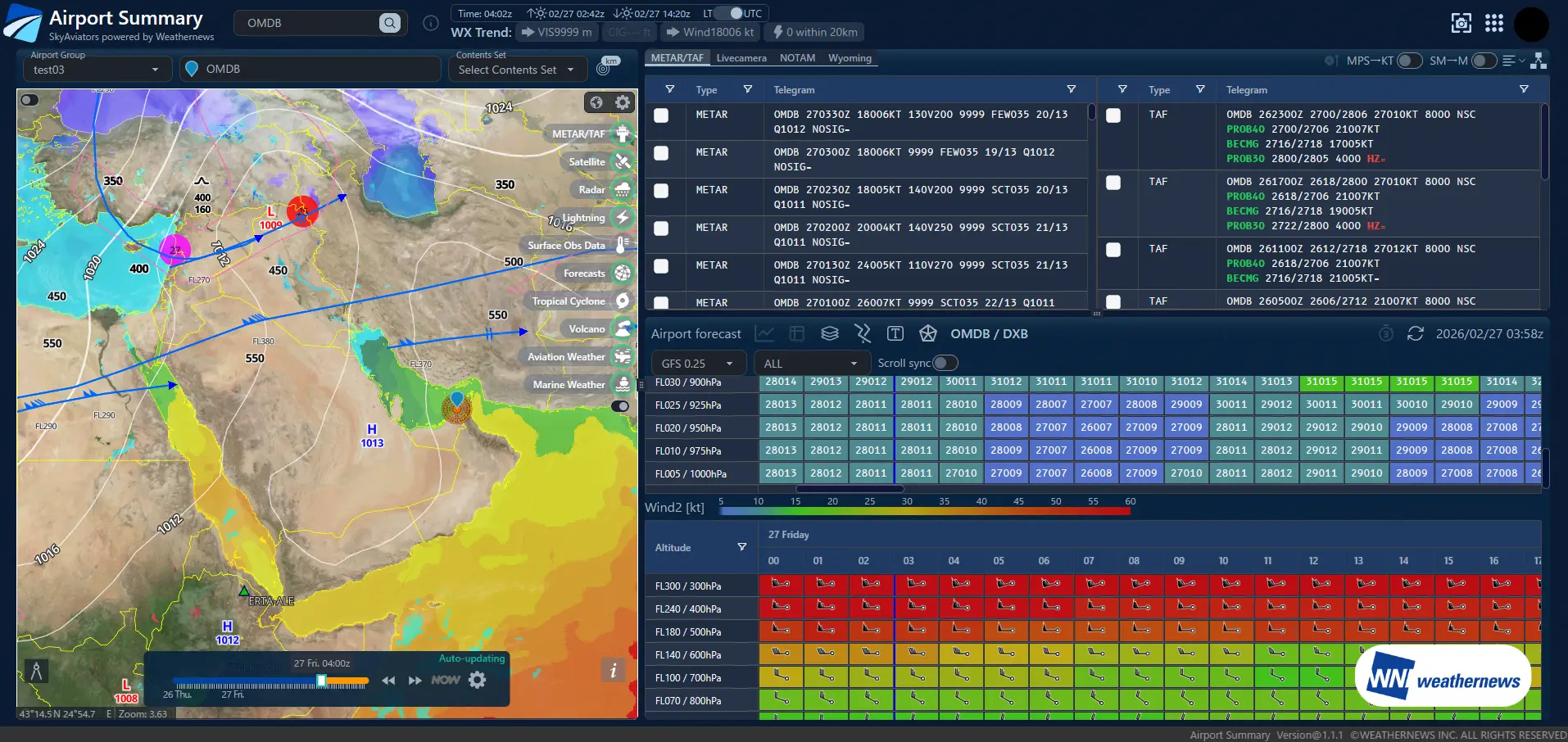
SkyAviators is a comprehensive weather intelligence platform developed by Weathernews for airlines. Powered by world-class meteorological data and decades of aviation weather expertise, it empowers operational decision-making when it matters most. The Airport Summary & Model Comparison feature integrates multiple numerical weather prediction models and ICAO-standard forecast reliability assessments into a single view. This enables users to quickly identify forecast discrepancies and uncertainty, supporting weather interpretation and decision-making aligned with airline operational policies.
Multiple numerical weather prediction models—including regional models, global models, and proprietary forecasts—are consolidated into a single view together with historical observation data.
Forecast reliability for each numerical model is visualized using evaluation methods based on ICAO standards.
Three numerical weather prediction models for the same region are displayed in parallel, enabling direct comparison under identical conditions.
Historical observations, current conditions, and future forecasts are seamlessly integrated into a time-series display.
Objective reliability assessments clarify which model should be used as the decision reference. This improves both the speed and confidence of Go / No-Go decisions, helping prevent delays in operational judgment.
Model reliability is standardized using ICAO-based evaluation methods, reducing reliance on individual expertise or personal judgment. This allows the entire team to apply consistent decision criteria.
When weather variability is high and decisions become challenging, multiple forecast models are compared and their confidence evaluated to provide reliable support for operational decision-making.
There is no need to switch between multiple websites or screens. By consolidating all relevant information into a single view, analysis time is reduced, allowing teams to focus on making decisions.
Please feel free to consult with us about implementation methods, features, or advancing specific considerations. We'll answer even the smallest questions.
We'll explain pricing details and provide specific content based on your site conditions so you can consider with confidence.
Free Quote
We'll explain in detail how to utilize features and the implementation process. Please feel free to consult with us.
Consider Implementation