Airline Weather
Industry Solutions
Explore real-world use cases and solutions tailored to each industry's unique weather challenges.

Construction Weather

Logistics Weather

Facility & Plant Weather

Municipal Weather

Retail Weather

Energy Weather

Dam Weather

Insurance Weather

Agricultural Weather

School Weather

Event Weather

Sports Weather

Road Weather

Railway Weather

Climate Tech

Broadcasting Weather

Coastal Weather

Airline Weather

General Aviation Weather

Drone Weather
Weather Solutions
Industry Solutions
Top PageWeather Solutions
Winter Storm to Bring Widespread Snow and Low Visibility to Europe Through Feb 15
February 13, 2026 Weathernews
From February 14 to 15, a cold-core low is forecast to track eastward across the northern Mediterranean. Combined with a trailing trough and colder air aloft, the system is expected to bring widespread snowfall to central Europe. Locally heavy snowfall is possible at some airports.
During peak snowfall periods, reduced visibility, lower ceilings, snow-covered surfaces, and deteriorating runway conditions may lead to operational disruptions.
Snow is forecast at major airports including Zurich (LSZH/ZRH), Munich (EDDM/MUC), Prague (LKPR/PRG), Vienna (LOWW/VIE), and Geneva (LSGG/GVA). In particular, Zurich and Munich airports may see heavy snowfall. However, snowfall amounts and timing remain subject to change depending on the evolution of the cold-core low and the associated cold air aloft. Meanwhile, at Rome Fiumicino Airport (LIRF/FCO), where the core of the cold-core low is forecast to pass nearby, temperatures are forecast to remain too high for snow. Instead, heavy rain, thunderstorms, and strong southerly winds are forecast, mainly around February 14.
Airport
Zurich Airport
Munich Airport
Prague Airport
Vienna Airport
Geneva Airport
City / Country
Zurich, Switzerland
Munich, Germany
Prague, Czech Republic
Vienna, Austria
Geneva, Switzerland
ICAO/IATA
LSZH/ZRH
EDDM/MUC
LKPR/PRG
LOWW/VIE
LSGG/GVA
Snow Timing
from 0900 UTC 14 Feb to 1200 UTC 15 Feb
from 1500 UTC 14 Feb to 1200 UTC 15 Feb
from 1500 UTC 14 Feb to 0900 UTC 15 Feb
from 1800 UTC 14 Feb to 1200 UTC 15 Feb
from 0600 UTC 14 Feb to 1200 UTC 15 Feb
Peak Snowfall Period
from 1800 UTC 14 Feb to 0000 UTC 15 Feb
from 1800 UTC 14 Feb to 0000 UTC 15 Feb
from 1500 UTC 14 Feb to 2100 UTC 14 Feb
from 0000 UTC 15 Feb to 0600 UTC 15 Feb
from 1200 UTC 14 Feb to 1800 UTC 14 Feb
Low VIS / CIG due to Snow Period
from 1800 UTC 14 Feb to 0000 UTC 15 Feb
from 1800 UTC 14 Feb to 0000 UTC 15 Feb
from 1500 UTC 14 Feb to 2100 UTC 14 Feb
from 0000 UTC 15 Feb to 0600 UTC 15 Feb
from 1200 UTC 14 Feb to 1800 UTC 14 Feb
Forecast Snowfall Amount (by 1200 UTC 15 Feb)
10–15 cm
10–15 cm
5–10 cm
5–10 cm
3–5 cm
Strong Winds ≥ 20 kt
NIL
NIL
NIL
from 0800 UTC 15 Feb to 1200 UTC 15 Feb
NIL
Minimum Temperature During Snowfall
-3℃ (from 0500 UTC 15 Feb to 0700 UTC 15 Feb)
-4℃ (from 0600 UTC 15 Feb to 0900 UTC 15 Feb)
-5℃ (from 0500 UTC 15 Feb to 0800 UTC 15 Feb)
-2℃ (from 0600 UTC 15 Feb to 1000 UTC 15 Feb)
-3℃ (from 0100 UTC 15 Feb to 0500 UTC 15 Feb)
Large-scale flight cancellations during winter are often not the result of unforeseen weather. Instead, they often come down to a critical challenge: how to assess forecast reliability within limited decision-making time.
・Even after reviewing the TAF, confidence in the forecast may remain uncertain. ・Numerical weather prediction models can provide additional support, but it is often unclear which model should be prioritized. ・There is little time to check historical performance or consistency across multiple models. ・In operational aviation meteorology, the ability to instantly compare, evaluate, and interpret multiple sources of information has become more essential than ever.
What airlines truly need is a simple, intuitive indicator that allows them to quickly and confidently answer one key question:How reliable is the forecast for this airport?
Explore real-world use cases and solutions tailored to each industry's unique weather challenges.
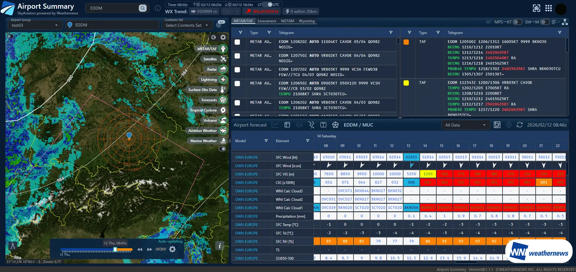
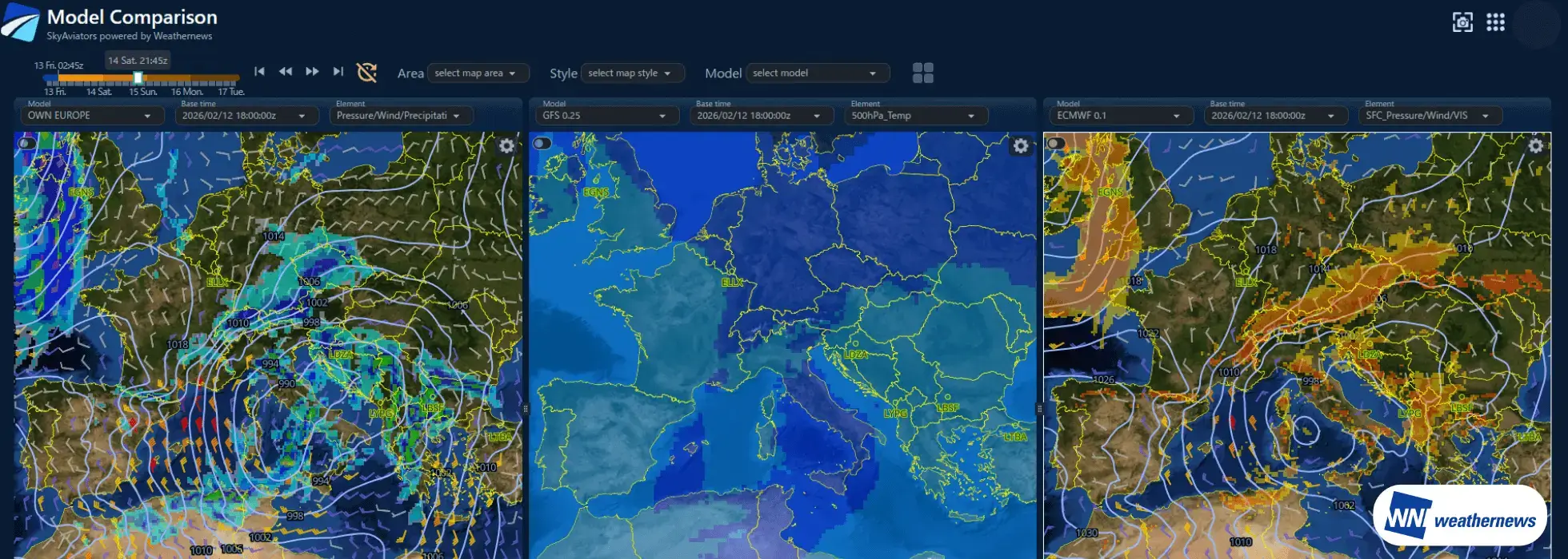
SkyAviators is a comprehensive weather intelligence platform developed by Weathernews for airlines. Powered by world-class meteorological data and decades of aviation weather expertise, it empowers operational decision-making when it matters most. The Airport Summary & Model Comparison feature integrates multiple numerical weather prediction models and ICAO-standard forecast reliability assessments into a single view. This enables users to quickly identify forecast discrepancies and uncertainty, supporting weather interpretation and decision-making aligned with airline operational policies.
Multiple numerical weather prediction models—including regional models, global models, and proprietary forecasts—are consolidated into a single view together with historical observation data.
Forecast reliability for each numerical model is visualized using evaluation methods based on ICAO standards.
Three numerical weather prediction models for the same region are displayed in parallel, enabling direct comparison under identical conditions.
Historical observations, current conditions, and future forecasts are seamlessly integrated into a time-series display.
Objective reliability assessments clarify which model should be used as the decision reference. This improves both the speed and confidence of Go / No-Go decisions, helping prevent delays in operational judgment.
Model reliability is standardized using ICAO-based evaluation methods, reducing reliance on individual expertise or personal judgment. This allows the entire team to apply consistent decision criteria.
When weather variability is high and decisions become challenging, multiple forecast models are compared and their confidence evaluated to provide reliable support for operational decision-making.
There is no need to switch between multiple websites or screens. By consolidating all relevant information into a single view, analysis time is reduced, allowing teams to focus on making decisions.
Please feel free to consult with us about implementation methods, features, or advancing specific considerations. We'll answer even the smallest questions.
We'll explain pricing details and provide specific content based on your site conditions so you can consider with confidence.
Free Quote
We'll explain in detail how to utilize features and the implementation process. Please feel free to consult with us.
Consider Implementation