Airline Weather
Industry Solutions
Explore real-world use cases and solutions tailored to each industry's unique weather challenges.

Construction Weather

Logistics Weather

Facility & Plant Weather

Municipal Weather

Retail Weather

Energy Weather

Dam Weather

Insurance Weather

Agricultural Weather

School Weather

Event Weather

Sports Weather

Road Weather

Railway Weather

Climate Tech

Broadcasting Weather

Coastal Weather

Airline Weather

General Aviation Weather

Drone Weather
Weather Solutions
Industry Solutions
Top PageWeather Solutions
Meteorological Characteristics of Radiation Fog at Delhi Airport (VIDP/DEL)
February 3, 2026 Weathernews
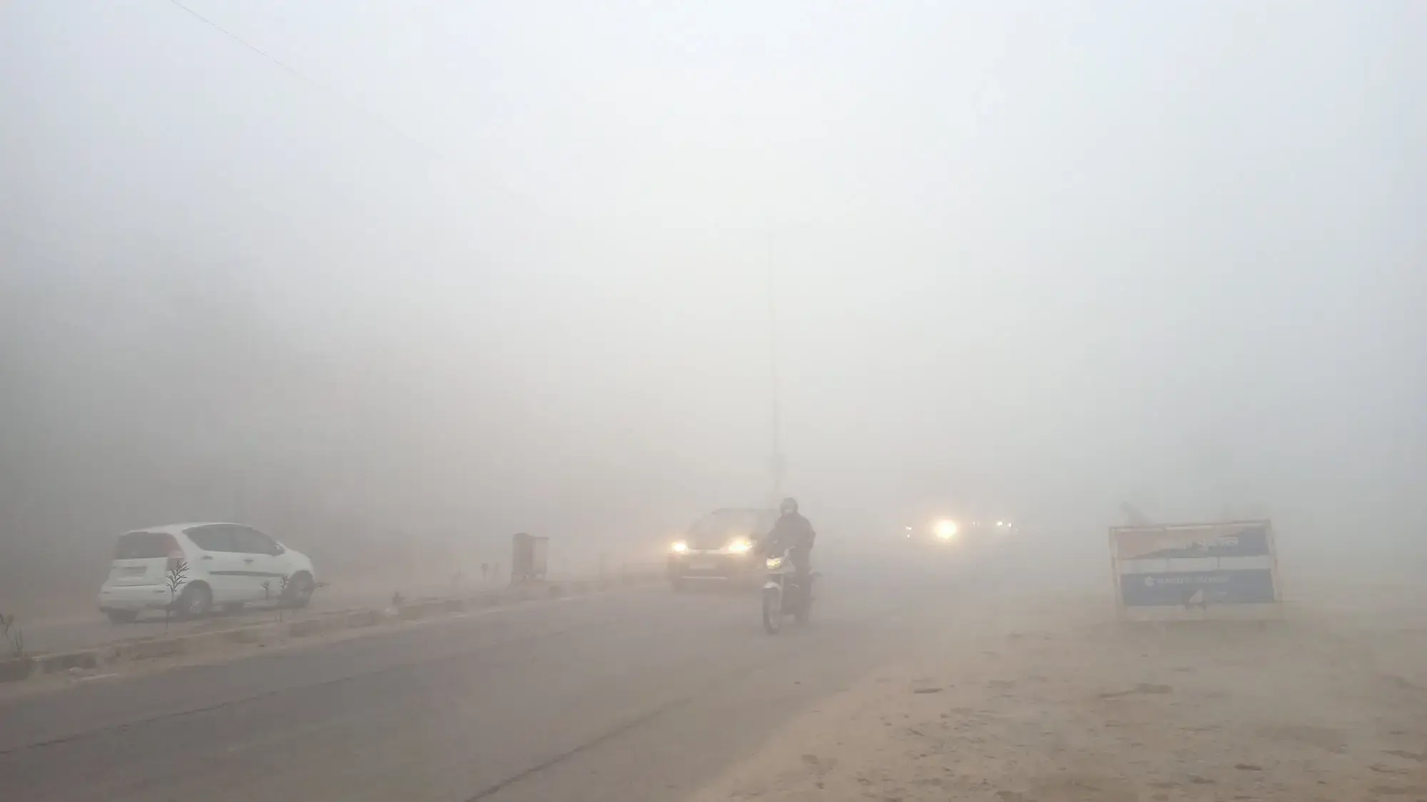
Indira Gandhi International Airport (VIDP/DEL), one of the largest aviation hubs in India, is frequently affected by dense fog during the winter season, causing significant disruptions to flight operations.
Due to the generally dry atmospheric conditions, the airport’s proximity to desert regions, and the pronounced presence of smoke from residential areas and industrial activities during the cold season, visibility-reducing phenomena occur almost daily throughout the year.
This article analyzes the formation mechanisms, occurrence patterns, and key operational considerations of radiation fog at VIDP from a meteorological perspective.
Item
Description
ICAO Code
VIDP
IATA Code
DEL
Official Name
DELHI Indira Gandhi International Airport
Operator
Delhi International Airport Private Limited(DIAL)
Operating Hours
24-hour operations
Location
South West Delhi, National Capital Territory of Delhi, India (approximately 16 km southwest of central Delhi)
Latitude / Longitude
28°34′07″N 077°06′44″E
Elevation
777 feet / 237 meters
Fog observed at VIDP Airport is predominantly radiation fog.
The onset of radiation fog typically occurs from late October through December, when moist air associated with the passage of Western Disturbances is cooled by strong nocturnal radiative cooling, leading to fog formation during the early morning hours.
The fog season generally extends from late October to late March, lasting approximately five months. Within this period, January experiences the highest frequency, with fog occurring on more than 25 days on average per month. This is followed by December, with approximately 15 fog days. In total, fog occurs on more than 60 days annually. Furthermore, when mist (MIFG) is included together with fog (FG), it is not an exaggeration to say that fog-related visibility reduction occurs almost daily in January.
The airport is located on a broad, largely flat inland plain, where strong nocturnal radiative cooling frequently occurs, contributing to fog formation.
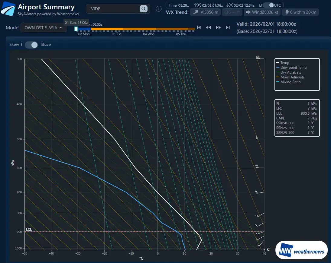
In general, during seasons when nocturnal radiative cooling is pronounced over the plains of India, a strong temperature inversion develops during the pre-dawn hours, extending from the surface to approximately 200 m above ground level. Within this layer, air temperature can increase by 10–15°C with height, creating a highly stable stratification that favors the development of dense fog.
Fog persists until this temperature inversion is eroded; therefore, accurate identification and monitoring of the inversion layer are critical for assessing fog duration and dissipation.
In general, fog is said to form when the temperature–dew point spread falls below 1°C, indicating near-saturation of water vapor. However, at VIDP, fog has been observed to develop even when the spread is around 3°C.
Based on past cases, fog formation at VIDP can be expected when the following conditions are met.
*SKC (Sky Clear) / NSC (No Significant Cloud) / FEW (Few) / SCT (Scattered)
*HZ (Haze) / FU (Smoke) / BR (Mist)
Parameter
Conditions
Season
Late October through late March
Time of Occurrence
From approximately 3 hours after sunset or after 1900 local time (1330 UTC) until around 0500 local time (2330 UTC)
Dissipation Time
Fog typically begins to dissipate around 1100 local time (0530 UTC)
Cloud Conditions
SKC/NSC, or FEW/SCT clouds around 10,000 ft
Temperature Trend
Prior to fog formation, weather conditions such as HZ, FU, or BR are often observed, with a temperature–dew point spread of 5°C or more. After sunset, rapid surface cooling causes the spread to decrease; fog formation begins once the spread falls below approximately 3°C. Continuous monitoring of surface air temperature is critical.
Wind
Calm winds are most common. Fog occurs under various wind directions, with no dominant directional preference. Wind speed is generally 6 kt or less.
Radiation fog at VIDP presents several challenges for operational decision-making, as outlined below.
To address these challenges, it is essential to compare multiple forecast models and establish a framework that enables objective evaluation of forecast reliability.
Challenge
Details
Difficulty in predicting onset timing
Fog can form even when the temperature–dew point spread is around 3°C, making it difficult to apply conventional fog prediction thresholds.
Uncertainty in dissipation timing
Fog duration depends on the timing of temperature inversion breakdown and may persist until around 1100 local time in some cases.
Forecast discrepancies among models
Significant variability exists among numerical weather prediction models in forecasting both fog onset and dissipation.
Reliance on individual experience
Operational decisions often depend on the judgment of experienced personnel, making it difficult to standardize criteria across teams.
Explore real-world use cases and solutions tailored to each industry's unique weather challenges.
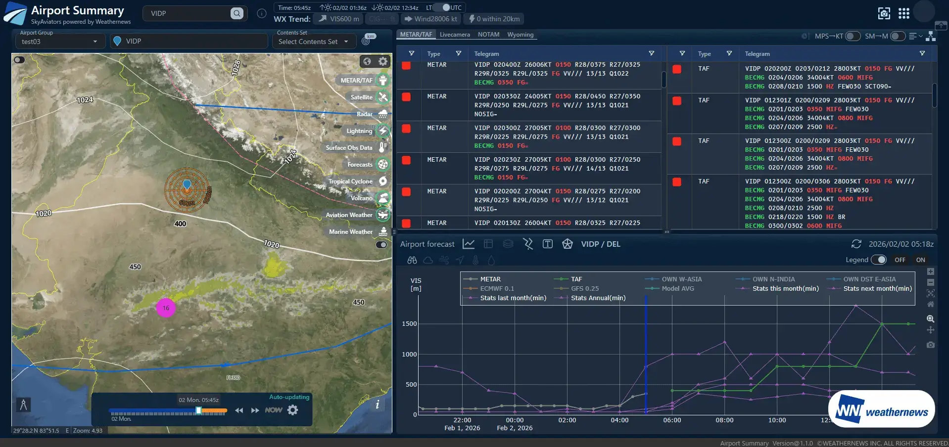
SkyAviators is a comprehensive weather intelligence platform developed by Weathernews for airlines. Powered by world-class meteorological data and decades of aviation weather expertise, it empowers operational decision-making when it matters most. The Airport Summary & Model Comparison feature integrates multiple numerical weather prediction models and ICAO-standard forecast reliability assessments into a single view.This enables users to quickly identify forecast discrepancies and uncertainty, supporting weather interpretation and decision-making aligned with airline operational policies.
Multiple numerical weather prediction models—including regional models, global models, and proprietary forecasts—are consolidated into a single view together with historical observation data.
Forecast reliability for each numerical model is visualized using evaluation methods based on ICAO standards.
Three numerical weather prediction models for the same region are displayed in parallel, enabling direct comparison under identical conditions.
Historical observations, current conditions, and future forecasts are seamlessly integrated into a time-series display.
Objective reliability assessments clarify which model should be used as the decision reference. This improves both the speed and confidence of Go / No-Go decisions, helping prevent delays in operational judgment.
Model reliability is standardized using ICAO-based evaluation methods, reducing reliance on individual expertise or personal judgment. This allows the entire team to apply consistent decision criteria.
When weather variability is high and decisions become challenging, multiple forecast models are compared and their confidence evaluated to provide reliable support for operational decision-making.
There is no need to switch between multiple websites or screens. By consolidating all relevant information into a single view, analysis time is reduced, allowing teams to focus on making decisions.
Please feel free to consult with us about implementation methods, features, or advancing specific considerations. We'll answer even the smallest questions.
We'll explain pricing details and provide specific content based on your site conditions so you can consider with confidence.
Free Quote
We'll explain in detail how to utilize features and the implementation process. Please feel free to consult with us.
Consider Implementation