Airline Weather
Industry Solutions
Explore real-world use cases and solutions tailored to each industry's unique weather challenges.

Construction Weather

Logistics Weather

Facility & Plant Weather

Municipal Weather

Retail Weather

Energy Weather

Dam Weather

Insurance Weather

Agricultural Weather

School Weather

Event Weather

Sports Weather

Road Weather

Railway Weather

Climate Tech

Broadcasting Weather

Coastal Weather

Airline Weather

General Aviation Weather

Drone Weather
Weather Solutions
Industry Solutions
Top PageWeather Solutions
Meteorological Background of the Complex Track of Tropical Storm No. 1 “Nokaen” East of the Philippines
January 27, 2026 Weathernews
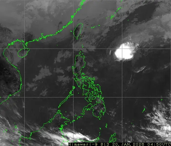
On January 15, 2026, Tropical Storm No. 1“Nokaen,” the first named system of the year, formed over the ocean east of the Philippines. Tropical storm formations in January are relatively rare in the western North Pacific.
East of the Philippines, Nokaen followed a complex track—initially moving northwestward, then turning northward and eastward, and eventually transitioning into a tropical depression. What meteorological factors lay behind this unusual and complex movement?
Table of Contents [ ]
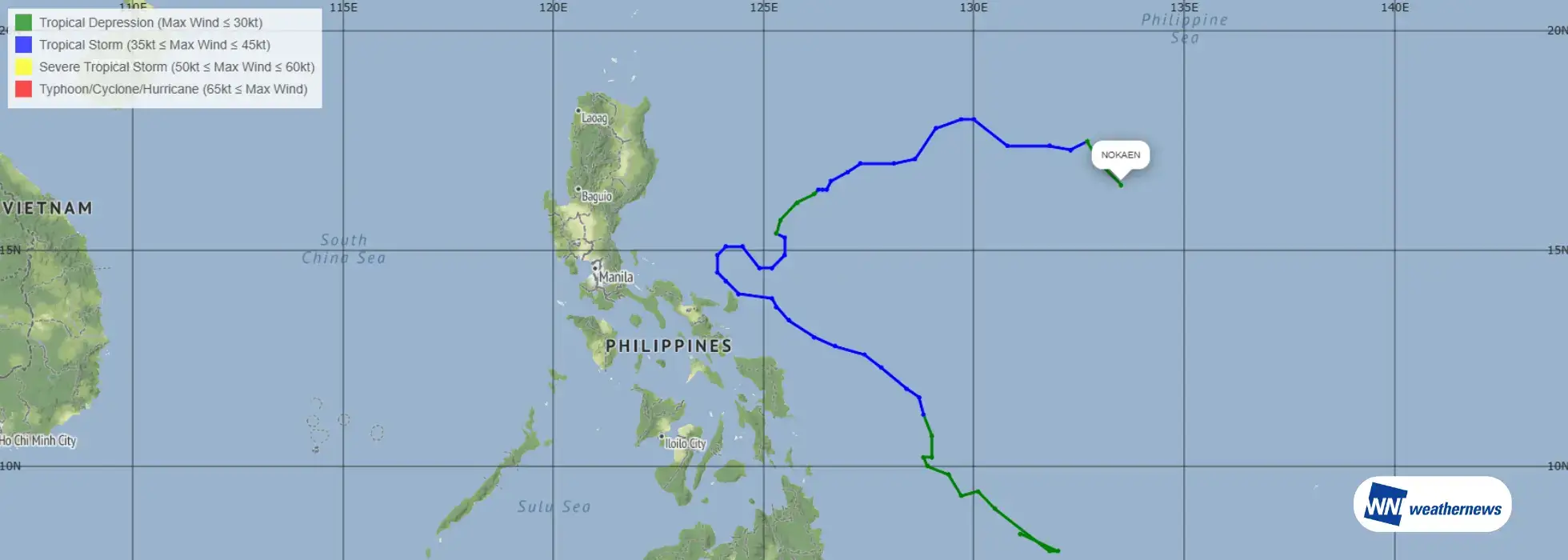
According to the Japan Meteorological Agency (JMA) ASAS* analysis, at around 06 UTC on January 15, a tropical depression located east of Mindanao Island, the Philippines, intensified into Tropical Storm No. 1 (NOKAEN). At the time of formation, the central pressure was 1000 hPa, with a maximum sustained wind speed near the center of 35 kt, moving northwestward at approximately 15 km/h. The system gradually intensified thereafter; however, development remained limited. At its peak, the minimum central pressure reached 996 hPa, and the maximum sustained wind speed near the center increased to 40 kt, indicating no significant intensification. Around 00 UTC on January 21, Nokaen weakened and transitioned back into a tropical depression east of the Philippines. *ASAS:Asia-Pacific Surface Analysis chart produced by the Japan Meteorological Agency
Item
Tropical Storm ID
International Name
Name Meaning
Formation Date
Data
T202601
NOKAEN
“Swallow” in Lao
January 15, 2026
The track of a tropical cyclone is governed by the interaction of multiple atmospheric factors.
Pressure Pattern: Highs and Lows A tropical cyclone is a type of low-pressure system and tends to move along the periphery of surrounding high-pressure systems. In particular, the Pacific subtropical high often acts as a “barrier” or a steering force, guiding tropical cyclones northward or pushing them along its edge.
Wind Flow Trade winds, which blow from east to west in low latitudes, tend to steer a tropical cyclone westward during its early stages of development. In contrast, the mid-latitude westerlies, including the jet stream, play a key role in turning a tropical cyclone eastward as it moves poleward.
Earth’s Rotation (Coriolis Force) Due to Earth’s rotation, a force acts to the right of the direction of motion in the Northern Hemisphere. As a result, tropical cyclones naturally tend to drift northward.
Influence of Land and Topography When a tropical cyclone makes landfall or interacts with mountainous terrain, its supply of warm, moist air—the system’s energy source—is disrupted. This can lead to weakening of the system or changes in its track.
In the present case, among these factors, the configuration of high- and low-pressure systems is considered to have played a primary role in influencing the tropical cyclone’s complex movement.
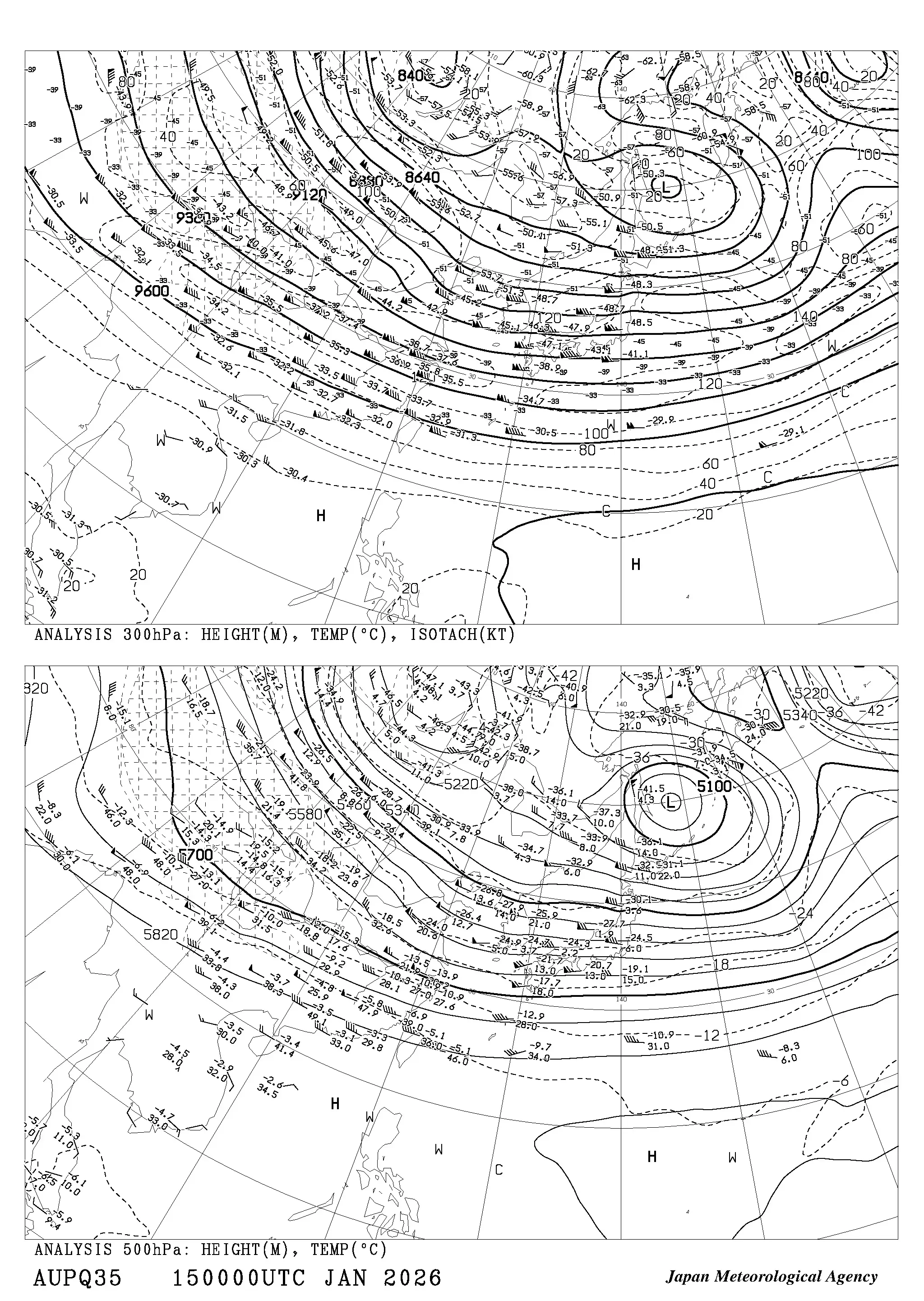
According to the 300 hPa upper-level analysis from JMA AUPQ35*, at 00 UTC on January 15, when Nokaen initially formed, high-pressure systems were present far to the east of the Philippines (northeast of the Nokaen) and to the west of the Philippines (northwest of the Nokaen). At that time, the high-pressure system to the northeast of Nokaen was dominant.
As a result, Nokaen moved northwestward along the periphery of the high, and this steering pattern persisted for some time.
After 12 UTC on January 17, the high to the northeast of Nokaen gradually retreated eastward, while the high to the northwest (west) became dominant. Under the influence of this high, Nokaen’s movement was blocked from the west to northwest, causing it to turn eastward.
In addition, by 00 UTC on January 19, a high-pressure system was also analyzed to the south of Nokaen. At this stage, Nokaen continued to move eastward along the edge of the surrounding high-pressure systems.
In this case, variations in the position and strength of surrounding high-pressure systems played a key role in producing Nokaen’s complex track.
Forecasting such tropical cyclone tracks is inherently challenging, as changes in steering flow can lead to large deviations in the predicted path. For this reason, it is essential to closely monitor the latest tropical cyclone information.
*AUPQ35 refers to the “Asia 500 hPa and 300 hPa Upper-Level Analysis Chart” issued by the Japan Meteorological Agency (JMA).“AU” stands for Analysis Upper, “PQ” denotes the Western North Pacific, and “35” represents the 300 hPa and 500 hPa levels.
Explore real-world use cases and solutions tailored to each industry's unique weather challenges.
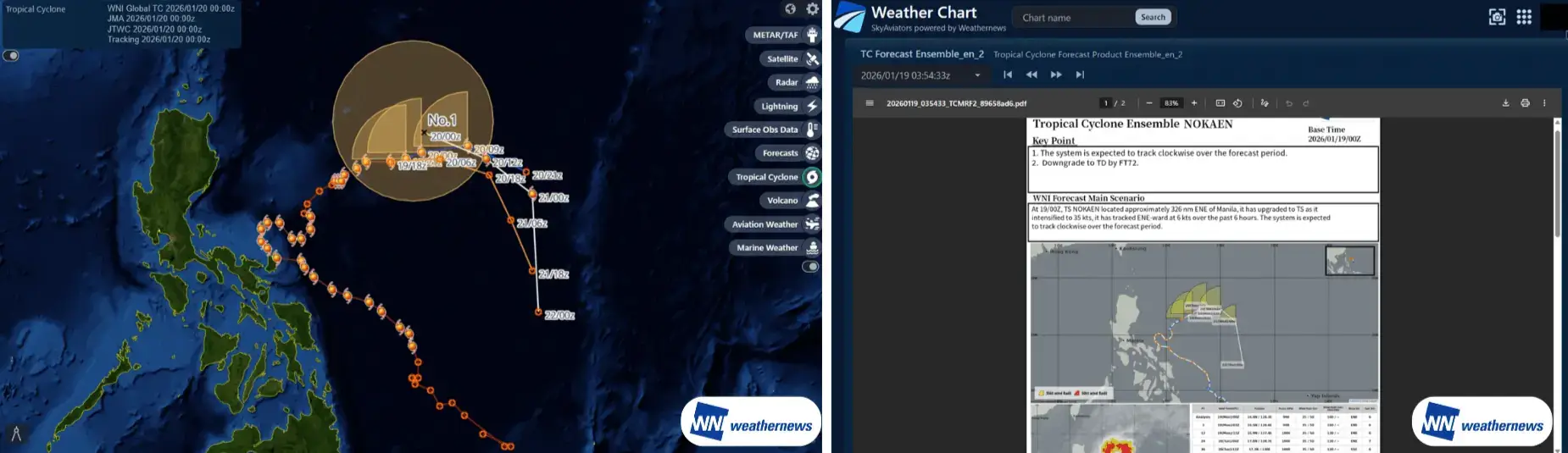
From historical tropical cyclone observations to forecast tracks from multiple agencies, all key information for operational decision-making is unified in a single platform. Impacted airports are automatically identified using threshold settings, with PDF briefings on track confidence and sea surface temperatures provided to improve the speed and accuracy of decisions during the tropical cyclone season.
Past observed tracks, current position, and forecast paths are seamlessly displayed, allowing intuitive understanding of track changes and trends.
Forecast tracks from multiple sources—including WNI proprietary analysis, the Japan Meteorological Agency (JMA), and the Joint Typhoon Warning Center (JTWC)—are shown on a single screen to visualize forecast spread.
Weather layers such as radar, satellite imagery, and lightning data can be overlaid to assess surrounding conditions from multiple perspectives.
Expert-prepared PDF briefings explaining track confidence and meteorological factors are provided, while impacted airports are automatically highlighted based on user-defined thresholds.
Comparing multiple forecasts reveals track variability and potential change risks, improving the quality of decision-making.
Viewing past, current, and future information on a single screen enables earlier action as a tropical cyclone approaches.
Automatic identification of impacted airports reduces manual checks and improves operational efficiency.
Expert briefings help establish a shared understanding across operations teams, field staff, and management.
Please feel free to consult with us about implementation methods, features, or advancing specific considerations. We'll answer even the smallest questions.
We'll explain pricing details and provide specific content based on your site conditions so you can consider with confidence.
Free Quote
We'll explain in detail how to utilize features and the implementation process. Please feel free to consult with us.
Consider Implementation